To understand the full benefits of EMODnet, users are kindly asked to describe how EMODnet supports them in their daily work and activities.
If you have developed an application using EMODnet products that you would like to share with us or if you use EMODnet data for other purposes, submit your use case by contacting secretariat@emodnet.ec.europa.eu.
The Horizon Europe MSP4Bio project used EMODnet multidisciplinary marine in situ data, including from Bathymetry, Biology and many other thematic data, to inform an Ecological-Socio-Economic (ESE) management framework used for science-based MSP to safeguard and restore biodiversity in a coherent European MPA network.
Croatian Geological Survey used EMODnet Geology, Bathymetry and Seabed Habitats data to develop the seabed substrate and geology maps within a project that aims to map the marine habitats of the coastal area of the Adriatic Sea up to a depth of 40 m and up to 200 m in protected areas.
Collaboration between EMODnet Biology, EMODnet Seabed Habitats and OBIS (Ocean Biodiversity Information System) has facilitated richer dataset publication and ensured the greatest volume of high-quality species and habitat data are available for reporting, assessments and informed decision making.
Outcomes: Users were able to apply a marine ecosystem services model to the Lithuanian sea to identify areas where anthropogenic impacts most greatly affected valuable fish provisioning areas and cultural coastal regions. Authors stated the information was particularly useful for regional authorities to apply an ecosystem-based management approach to marine spatial planning.
How EMODnet Seabed Habitats helped the user: EMODnet provided best available and free substrate data for the Lithuanian portion of the Baltic Sea.
This study was published by a group of authors, including representatives from a range of universities and research organisations. The lead author is the University Technology Sydney’s fish ecology lab, which aims to provide novel research to inform on the sustainability of the oceans and their fish populations. They actively engage in public debate on a wide range of issues affecting the marine environment, and also act as a hub for student research training. Their studie
The ADRIPLAN project (10 December 2013 until 10 June 2015) was funded by the European Commission and worked towards an ADRiatic-Ionian maritime spatial PLANning (ADRIPLAN). The project focused on improving the ongoing process to develop Maritime Spatial Planning (MSP) in the region to overcome barriers of full participation of all neighbouring countries in the process.
Outcomes:Researchers were able to model the suitable habitat for European hake, Merluccius merluccius, in their first year of life (0-group) in the Mediterranean Sea. The results show that hake nurseries require stable bottom temperatures, low bottom currents and a frequent occurrence of productive fronts in low chlorophyll-a areas in order to support successful recruitment, with conditions occurring recurrently in outer shelf and shelf break areas. This prediction explains the role of unfavourable environmental conditions on low recruitment in past years.
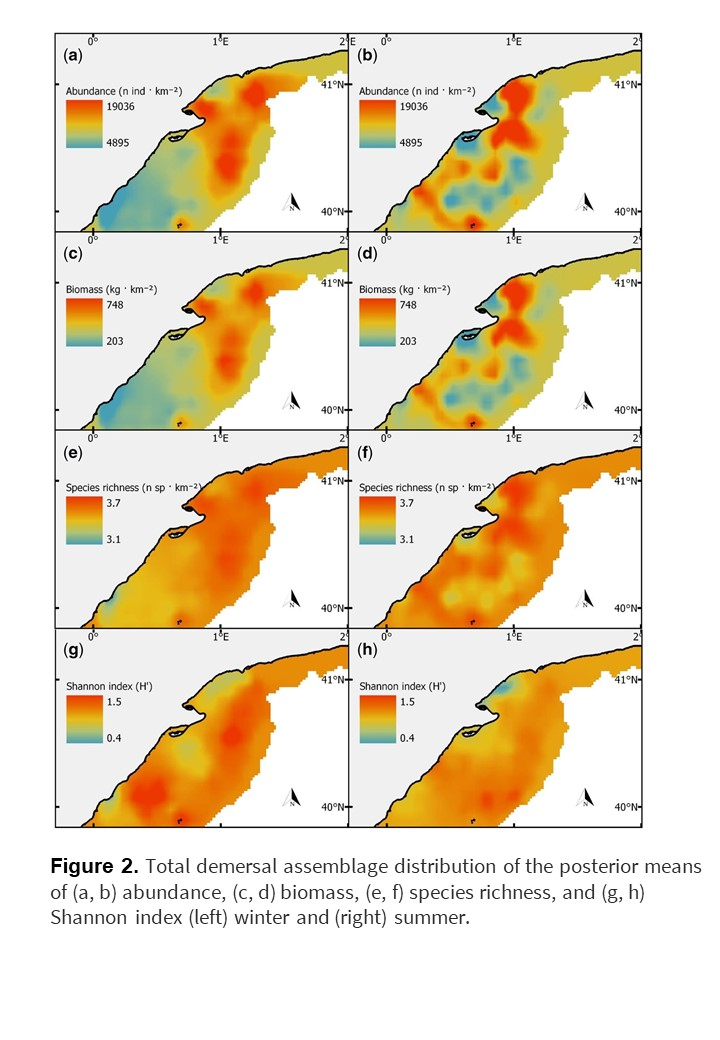
The Institut de Ciènces del Maris (ICM) used EMODnet Seabed Habitats classified substrate types described in the broad-scale predictive habitat map for Europe (EUSeaMap 2019) to model spatial patterns of abundance, biomass and biodiversity of demersal communities of the North-West Mediterranean Sea.
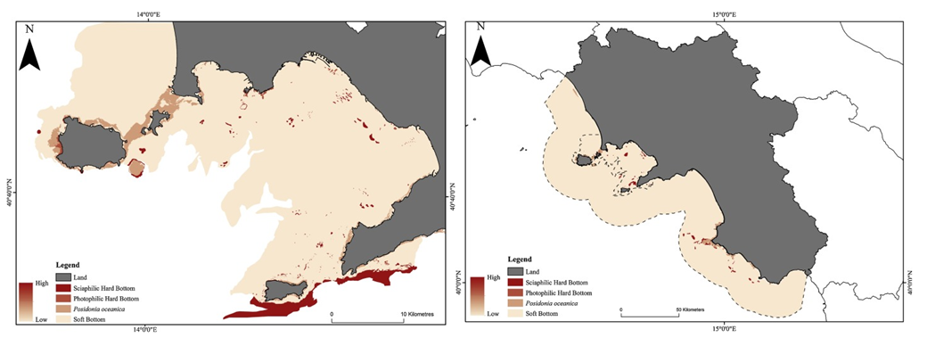
The National Interuniversity Consortium for Marine Science (CoNISMa) conducted a study to assess the natural capital across the Gulf of Naples and the wider Campania region, areas of importance to Italy’s economy. EMODnet Seabed Habitats broad-scale habitat map for Europe (EUSeaMap 2019) supported the authors’ research by providing vital data on habitat boundaries within the broader Campania region. This resource allowed the authors to identify four main macro-habitats which could be used to quantify the value of marine natural capital stocks.
Outcomes:Based on the study of morphological species diversity and distribution, authors were able to re-defined the circalittoral zone in the Azores islands.
How EMODnet Seabed Habitats helped the user:EMODnet provided the best data source to represent marine benthic habitats in the Azores.

 Ozren Hasan; b) Slobodan Miko, c), d), e) Ozren Hasan, f) Ante Žuljević")